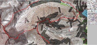
DeCaLiBron Loop Hike Topo, Via North Ridge of Mt. Democrat
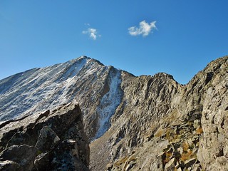
The North Ridge of Mt. Democrat, oh that it were longer! 0.5 miles of fun scrambling does not make up for the 6+ mile boggy approach.
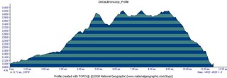
This elevation profile is not quite accurate. 4900 ft is in the right ballpark, for the elevation gain, but the distance is short by about a mile!
Doug and I decided to squeeze in a few more 14’ers before winter and so we aim for DeCaLiBron (De=Democrat, Ca=Cameron, Li=Lincoln, and Br=Bross). I’m not sure why it’s called DeCaLiBron and not DeCaLiBross, but that’s a topic for some other time.
To make it more interesting, we decide to climb the north ridge of Democrat, then climb Cameron, Bross, and Lincoln. Ending the day by descending the Lincoln Amphitheater, to get back to the truck above Montgomery Reservoir.
Launch: 5:50am
Begin Mt. Democrat North Ridge Scramble: 9:40am
Summit Mt. Democrat: 10:40am (We take a short lunch break on the summit).
Summit Mt. Cameron: 11:40am
Summit Mt. Bross: 12:20pm
Summit Mt. Lincoln: 1:12pm
Begin Descent of Mt. Lincoln via the Amphitheater: 1:25pm
Finish: 4:15pm

My Bivy in the Big Agnes Seedhouse, Trailhead above Montgomery Reservoir

Doug making progress up a dry section of the Montgomery Reservoir 4wd road. This might be the only dry section of the 6 miles we trudged!

Moon Setting on North Side of Mt. Lincoln

Typical road conditions! We spent a lot of time trying to avoid deep water, getting gunked up by mud, and wrestling with willows.

Traver Peak (13,852 ft) in Alpenglow. At least we had a beautiful morning!

About 1 hour into our hike, we have 3 miles left to reach the north ridge of Mt. Democrat. I look to the south west and get this picture of our way ahead.

Taken from the same spot as the prior picture, but looking back down Montgomery Reservoir 4wd road. See the boggy puddles? Ick!

At 8am, we are still about a mile from the ridge, but finally hiking on solid ground. It feels great, even though the hiking is now more steep and windy (we are above treeline now!). The ridge on Democrat is starting to feel more real and we are both getting excited to be scrambling.

Decision, Decision! We are on the slopes leading to the north ridge. Which way do we want to go? There are no trails, so we can choose our own adventure. We head right up the middle of this knobby mound, picking our way up the grassy bits in between boulders.

Taken from the same spot as the last picture, but looking back where we came from…wow, how beautiful!

When we get on top of the mound, a rocky ridge leading west is in front of us. We check the map, just to be sure, but it’s obvious where we need to go!

You can see Doug, in orange, picking the best line through the last of the 2nd class before the north ridge begins. It was very windy in this section of the hike, so we both put our hoods up.

At 9:30am, we stop to put helmets on and have a snack. We are finally at the north ridge and psyched about the bouldering!

Doug scrambling on the ridge. There were several different notches in the ridge. Behind him is the first one we encounter.

Doug descending the first notch. Like all the notches, it has a feeling of exposure, but it’s not difficult.

Looking back at the descent of the first notch. Taken from the same spot as the picture of Doug descending, above.

Looking at Mt. Democrat from the ridge. We are making good progress as the notch is fun and the rock is mostly very solid.

Here I am scrambling out of the 1st Notch (picture courtesy of Doug). When I get to the top, we stare down at the 2nd notch. It has a lot of exposure, and features a chockstone crossing.

Doug took this picture of the chockstone, and the exposure on both sides! On either side of the chockstone (the size of a large coffee table) is a drop of several hundred feet. Thus, neither of us stood there for very long!

A picture of the down climb leading to the chockstone. I took this picture just after I crossed the notch, via the chockstone.

Halfway up the north ridge. The rest of the route is fairly mellow with a mixture of 2nd and easy 3rd class. There is still some exposure, so it’s not completely easy.

Taken from the same spot as the picture of Doug, above. I’m just looking back at the way we came, which is from the verdant Platte Gulch!

Doug took this neato picture of me on the pseudo “knife edge” of Democrat. On my left, it drops off several hundred feet and on my right it’s probably only 100 ft. On our way up, we observed, if you have to fall, fall to the right. Most often it was less severe.

The crazy masses! This is what we had to look forward to, after 8 miles (5 ish hours) of complete solitude. I was not at all excited, in fact I remember being slightly depressed as I took this picture.

Summit of Democrat (14,152 ft) – We definitely earned it.
After summiting Democrat, we took a 10 minute break. I took out my bagel sandwich for lunch. I was really hungry since we had been going at a fairly moderate pace for 5 hours. All of a sudden some sort of retriever dog lunged forward and snatched the sandwich out of my mouth! It managed to clip on of my fingers with it’s teeth, in the process.
My finger hurt and I was livid; what kind of inconsiderate person lets their dog roam around unleashed on top of a mountain? I belted out, whoever owns that dog owes me a sandwich! An older lady said, “Well at least you didn’t get bit!”. So, my response was, “Well, your dog did bite my finger and then ran off with my sandwich. What am I supposed to eat? Why don’t you put your dog on a leash?”. The lady was so defensive and it was obviously useless dealing with her, but my blood was boiling.
Doug managed to grab half of my sandwich back from the dog, which was awesome. At least I would be able to eat something! I dusted the dirt of my sandwich, thanked the heavens that I had my tetanus shots, and decided I had enough of Mt. Democrat. It was probably the worst summit experience I have ever had and I was looking forward to (shortly) experiencing another summit in order to calm down. I really needed to get away from that lady!
We decided to run/jog the rest of the peaks, so as to finish them as quickly as possible. There were some clouds in the sky, so we hoped not to get caught up in something. Also, the descent from Lincoln Amphitheater would be a challenge in dry conditions, so we didn’t need to add any extra drama. We made a beeline for the saddle between Mt. Democrat and Mt. Cameron, making down there in about 10 minutes.

The saddle between Mt. Democrat and Mt. Cameron. Thank goodness for Doug and his dry, sarcastic, and witty attitude. I was still steaming about my sandwich and here he is making faces. It made me laugh.

The masses heading over to Mt. Cameron (or coming back). Notice how 50% of the people are wearing jeans, 20% are wearing shorts (and their not from convertible pants), and 50% do not have backpacks. I am just amazed how little respect people have for the mountains and for their own life.
After I took this picture, every time I encountered a person who was prepared and obviously belonged in the mountains, I smiled and said something nice. My peers were also surprised at the cavalier attitudes and lack of preparation by the vast majority of people in this area.

Here I am nearing the summit of Mt. Cameron. Mt. Democrat, and the north ridge are behind me!

Doug waiting for me on the summit of Mt. Cameron (14,238 ft). He was running from peak to peak, while I was jogging. We rock!

Summit of Mt. Bross (14,177 ft)

Looking back at Mt. Cameron and Mt. Lincoln…out next destination.
After Mt. Bross, we had to head back up Mt. Cameron to get over to Mt. Lincoln. Luckily, there is a diagonal trail which bypasses most of Mt. Cameron.

After hiking for 7 hours, we are finally ascending Mt. Lincoln. It is last on the itinerary, so soon, we will be headed back to the truck. We’re very excited to be wrapping things up.

Looking back at Mt. Cameron, while I was ascending Mt. Lincoln. It’s really flat!

Mt. Bross from the same spot as the last picture. We were surprised to see a pair of Land cruisers drive up the road, and park about 200 ft from Mt. Bross’ summit!

Looking down into Platte Gulch and the 4wd approach road we hiked up earlier in the day! It was impressive to look down into the valley and see our long approach. Wheeler Lake is beautiful, perched on a bench, above the Gulch.

Finally, the summit of Mt. Lincoln (14,291 ft)…my Garmin says 14,283 ft. Close enough!

Happy Climbergirl on Mt. Lincoln. Ready to descend and get away from the crowds.
ON the summit of Mt. Lincoln, there was a group of 4 women in their late 20s to mid 30s. Two of them had eastern European accents. They were all sharing a cigarette and passing it around. They were talking really loud about mountaineering. I was trying to ignore them, but the smoke was blowing into my space and their yakking was annoying.
I was displeased, yet again, and tried to move upwind and far enough away so that I didn’t have to listen to them.

I found Doug sitting down slope a bit, in the direction we needed to go. Smart guy.

Doug took this, right before we dropped into the Amphitheater.

Doug descending Mt. Lincoln. Montgomery Reservoir is peaking out in the distance.

Looking back up at the first of two “cliffy” areas we encountered on the descent. The descent wasn’t hard, but it was just never ending piles of tallus and scree. There was really no flat trail and much of the rock was loose, so it was tedious.

This was taken from the same spot as the last picture, it’s just looking down slope. Doug is consulting some of the printed out pictures we got from 14’ers.com trip report. The pictures helped us to skirt the “cliffy” sections and give us a general sense of the way to go…but it was really just about “going down”.

Looking back at the 2nd Cliffy area. The rocks in this spot were about watermelon sized, quite awkward to navigate.

Further down the scree/talus river that exits the amphitheater. Little orange dot in the distance is Doug. This flat section was probably the best part of the descent. There were a few places without rocks, where we could walk without fear of tumbling or having the rock roll out from under foot.

Taken from the same spot as the photo above, just looking back at the way we came. Arduous!

It has now been 1.5 hours since we left the summit of Mt. Lincoln. We have over an hour to go, in order to reach the truck. We can finally see Montgomery Reservoir, so at least we know we’re getting close!
At the base of the rock river, we spot a huge cairn (it’s like 6 ft tall). We hike over to the cairn and look for a descent trail. After bush wacking for 15 minutes we give up. We call the cairn “stupid cairn” and search for another way down.
Doug spots a steep collection of boulders heading downslope. We both agree that boulder hopping is way more preferable to bush wacking willows, so we give it a shot. It turns out to be a great way down, and eventually leads to a…TRAIL!


This is a really pretty waterfall we saw on our way down the boulder hopping bit. Somewhere around this area, there was a very small single track trail. It was muddy in spots, but we followed it for about 20 minutes. At one point, we passed a litter hanging in a tree, which must be stored permanently for mountain rescue.
Eventually, the single track disappeared into another gully of boulders.

When we got to this spot, we knew we were going to be connecting up with a real trail which would lead back to the truck. As we descended the boulders, we kept our eyes peeled for a trail to the left. Eventually, we found it and then 10 minutes later we were back to the truck.

Looking up the Platte, towards a mine that we passed at oh-dark-thirty.

Parting shot of the final descent from Lincoln Amphitheater. Coming down Mt. Lincoln using this route is a tricky and extremely tedious descent when done in the fall! But, if you are fit, have experience scrambling, know how to route find, it’s doable. I would not recommend it, though!
If you want to go down this way, better to do it in winter so as to avoid the rocks. Glissading this route would be so much more fun!

Oh how we deserved these cold ones!
Tags: 14er, DeCaLiBron, Lincoln Amphitheater, Mt. Bross, Mt. Cameron, Mt. Democrat, Mt. Lincoln, North Ridge of Democrat