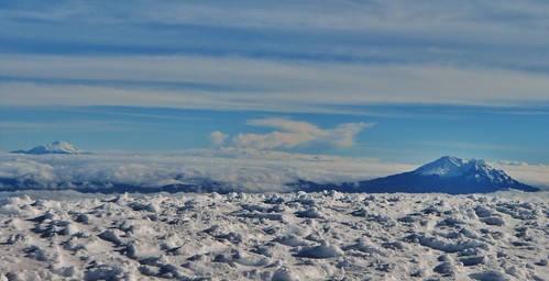
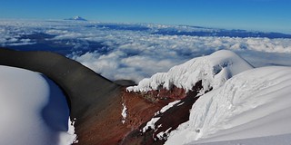
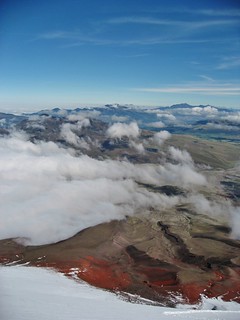
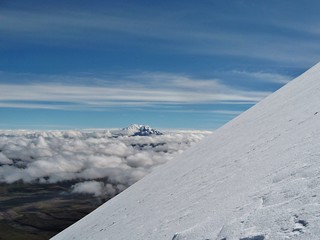
Antisana and Chimborazo from the summit of Cotopaxi

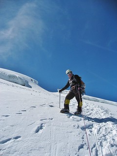
Tilden and Clare on the Summit of Cotopaxi
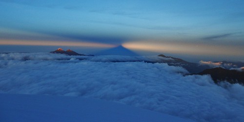
The Shadow of Cotopaxi and the Illinizas (see the previous day’s post!)
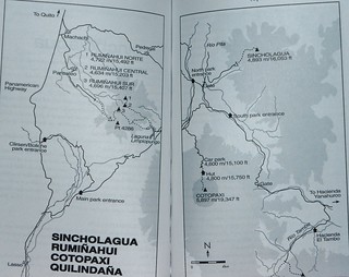
The Map
Our Guide, Rafael (photo courtesy of Tilden)
Times
12:00am: Trail Head at 15,100 ft
01:20am: Hut at 15,750 ft *took a 10 minute break
02:20am: Snowline at 16,000 ft *took a 10 minute break to don crampons and rope up
06:05am: At 18,600 ft Watched Sunrise and shadow of Cotopaxi appear by the Illinizas
07:45am: At 19,347 ft On Summit!
08:25am: Began Descent
11:25am: Back at Trail Head
Clothes:
LaSportiva Trango Evo GTX Women’s Boots (The Nepal Evo GTX would have been way better!)
Wool Knee High Socks
OR Knee High Mountaineering Gaiters
Ski Booties (Neoprene covers for my inadequately insulated boots!)
Fleece Lined Spandex Running Tights
Long Sleeve Patagonia Capilene silk weight top
NF half zip soft shell (took it off on the way down)
Western Mountaineering Down Vest
Marmot Windbreaker with helmet compatible hood
NF 600 fill Down Jacket (in the pack)
Neoprene Ski Balaclava
Polypro beanie hat (for under my helmet)
rei liner gloves
OR Alti Mountaineering Mittens
Gear:
Petzl Climbing Helmet
Ice Ax (rented, adequate but heavier and longer than the one I own)
Crampons (rented petzl’s from the 1990s…kinda heavy and slightly rusted).
Ski Goggles
Glacier Glasses
BD Alpine Bod Harness
2 Locking Carabiners
2 prussiks with tiblocs
REI Women’s Flash 50L backpack
Chemical toe warmers (wearing one pair and an extra just in case)
Chemical hand warmers (wearing one pair and an extra just in case)
Garmin E-trex GPS Reciever
SPOT Personal Beacon
Camera
BD Headlamp
Minimal First Aid Kit (~1 lb including backup headlamp, tape, handwarmers, sunblock, etc.)
Food:
2 Liters of water, Nalgene in an insulated container and a store bough water bottle full of gatorade
5 handfulls of peanut butter stuffed pretzels
Ruffle Chips (didn’t eat)
2 packages of cookies (ate one)
Dark Chocolate Almond Cliff Bar
Justin’s Chocolate Almond Butter
Banana and 1 slice of wheat bread w/jam (for “breakfast” at 11pm before we started hiking)
Cliff Shot blocks (didn’t eat)
Experience:
Having heard from multiple sources that “Cotopaxi is just a walk up”, I was expecting it to be like many of the 14ers in the Sawatch Range; just a steep slog. It was nothing like my expectations and, according to the route that we took, it was definitely not “just a walk up”. Cotopaxi does have crevasses and steep (45+ degree) snow slopes and it reminds me much more of Mt Rainier than one of our non-glaciated peaks.
First Section (15,000 ft to 16,000 ft):
Even though this part was not on snow; it was challenging. The trail was not always packed dirt, so much of the way ones feet would sink into the soft volcanic dirt. We did this section from ~12am to ~2am, so one is potentially fighting to stay awake. The wind was howling when we climbed this section and at times it was very difficult to see the trail as we were in a fog.
Second Section (16,000 ft to 17,500 ft):
For the first 500 ft, the snow was moderately sloped (~20-30 deg), but somewhere around 16,500 ft it steepened drastically. I was very happy that we were roped up as we climbed a ~45-50 deg snow slope. It was a long diagonal upward traverse, where the mountain was on our left. At times, I could reach out just a little bit and touch the uphill slope. The bootpacked trail was about 18 inches wide, so just wide enough to walk on with both feet side by side. There were very few switchbacks and sometimes the trail went straight up the slope and I felt like I was climbing a ladder. Rafael was cleaning off the kicked steps for us as we went, so even though it was steep, I felt very safe. This traverse is important to execute swiftly as there is a crag above this section with the potential for rockfall.
Third Section (~17,500 ft to Summit)
After the long traverse on the steep slope, the path continues to traverse, but along a bench where there are a few ups and downs over drifts of snow. At ~18,600 ft, there is a flat area (just past some sulfer vents) which is the last flat spot before the summit. After this spot, there is one more sustained steep section (~40 deg) and then you arrive at the summit.
I do not have an elevation profile of the climb because, although I did have my Garmin GPS receiver, I do not own the topographic map points so I have no way to map the route. All I can say is that it’s a very sustained route. It was not very far distance wise, being only 6.6 miles total for the round trip. There was ~4,250 ft of gain.
The summit of Cotopaxi is amazing. We were fortunate to have a perfectly crisp, bluebird day. The clouds were thousands of feet below us and blanketed out the horizon. Peaking through the clouds were the famous Volcanoes of the “Alley”. It was incredible being up there! Because of the nice weather, we were able to enjoy the summit for 45 minutes, but then it was very important to go down. The snow was softening, so Rafael didn’t want to put us at risk on that steep, traversing snow slope!
Pictures from our day:
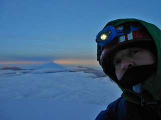
Me at Sunrise, just 500 feet from the summit of Cotopaxi! Behind me, you can see the twin summits of the Illinizas and the shadow of Cotopaxi.
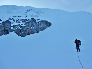
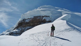
The Path Forward. Taken from the same spot as the previous picture, but just looking at Tilden and Rafael. We just have one final steep slope to conquer before we are on the summit. At this point, my toes have been numb for a couple hours and I can’t wait to be in the sunlight!
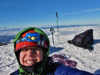
Selfie on the summit!
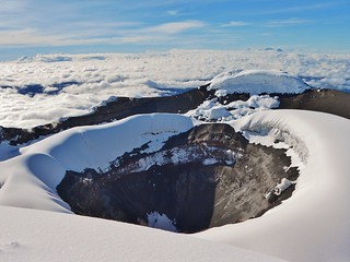
Cotopaxi Crater (There are sulfer fumes actively coming out of this cauldron!)
Crater Rim
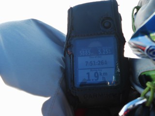
Garmin on the summit!
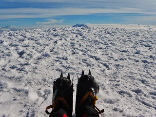
The Summit View!
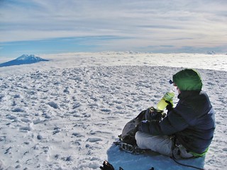
Hydrating on the summit. I only drank 0.75 liters on the way up. That’s not enough for 7.5 hours of exertion! I was very thirsty on the top of Cotopaxi and I could have easily consumed an entire liter right then and there…but I had to save some for the trip down.

Tilden on the summit!
Climbergirl on the way down. Courtesy Tilden Daniels.
The view downward! Courtesy Tilden Daniels.
Typical gradient! Courtesy Tilden Daniels.
After climbing Cotopaxi, we went back to the bunkhouse and had a continental breakfast. Rafael had arranged for us to have a post climb meal and I thought that was extra awesome. We stuffed our faces and then we drove back to the Cuella Da Luna lodge. The weather at the lodge was gorgeous, so I took a nap on the grass and then dozed a bit while rocking in one of the hanging chairs. Ahhhh, luxury!
Since it was Thanksgiving the day prior, and we missed out on Turkey, Tilden and I later shared a bag of Turkey Jerky. We then went through our gear and got our bags ready for the journey home. Time flew by and soon we were stuffing our faces with another amazing dinner. I had chicken with fries and mushrooms and a fresh salad. Tilden and Rafael noshed on the most amazing looking steaks. We all drank beer…in celebration of our fabulous day!
I was a little sad that the trip to Ecuador was winding down, but I missed Dennis so in that respect I was happy to be heading home. Climbing Cotopaxi was amazing and it sparked a desire to try a 6,000 meter peak. Maybe it will be Chimborazo!
Tags: 19er, Cotopaxi, Cotopaxi National Park, Ecuador, Mountaineering, Snow Climbing