I ran with Barry & Anne from the North to the South Rim of the Grand Canyon. It is 24.4 miles of running with over 10,000 ft of elevation gain/loss. Start: 4am and Finish:12pm (Anne finished at 1:40pm). With 4 bathroom/snack breaks and a stop to tape my hideously sprained ankle, running time was ~7 hours. A most excellent adventure!!!
GPS Elevation & Speed Plots:
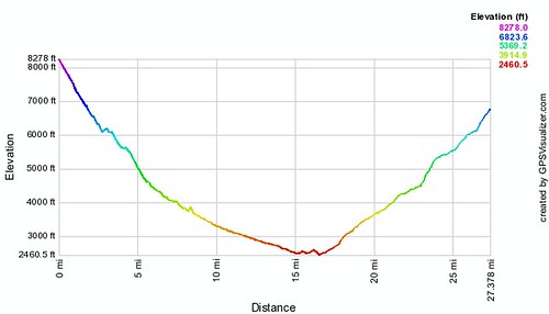
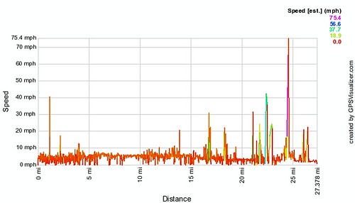
Please be aware, there’s error in almost every data point for the ascent of the South Rim. As a result, the speed & elevation profiles show that we went 27 miles instead of 24.4. Dennis & I spent several hours reducing the error (as it falsely reported we had run 30 miles)! I did not feel like spending any more time with it, so please forgive the data innaccuracy!
R2R Video:
Times & Places:
North Rim (8250 ft, mile 0) 4am
Supai Tunnel (6800 ft, mile 1.8) 4:30am
Roaring Springs (5200 ft, mile 4.7) 5:00am
Cottonwood Campground (4080 ft, mile 6.9) 5:45am
Phantom Ranch (2480 ft, mile 9.8) 8:00am
Colorado River (2400 ft, mile 14.5) 8:20am
Resthouse (2480 ft, mile 16.7) 9:00am
Indian Gardens Campground (3800 ft, mile 19.8) 9:40am
South Rim (6860 ft, mile 24.1) 12:08pm
Gear:
Platypus DayPack & 70 oz camelback bladder
Petzl Emergency Headlamp (not bright enough)
Sony Camera
Sunblock
Chapstick
Neosporin
8oz belt attachable drink
Cloth pouch for camera/gu’s
Rescue Whistle
Sleeping Pills
Ibuprofen
Moleskin
Mini-leatherman
Pocket warmer
Komperdell Trekking Poles
Food:
Two Gu’s (Espresso & Apple/Cinnamon – Ate Both!)
One Shotblock (Margherita Flavor-Ate it!)
Half bag of Peanut Butter Filled Pretzels (Ate 5 during run, the rest in shuttle back)
4 sticks of dried Spicy Mango (Ate in Shuttle)
1 Apple (Ate it!)
1 Protein Bar (Did not eat, instead I had a homemade Brolley Bar)
Clothing:
Saucony Running Shoes
Gators (by runningfunky.com!)
Shorts
Tank Top
Arm Warmers
Waterproof Windbreaker
Polypro gloves
Polypro beanie
Sunglasses
Extra Pair of Socks
Training Regime:
Ran Track Practice Tuesdays (Phidippides Track Club, Denver)
Ran Trail Running Sessions Sundays (Golden Trail Running Group)
Competed in a Half Marathon with lots of elevation gain/loss (Horsetooth Half)
Climbed in Gym Midweek
I climbed & ran whenever I could
My goal was to be able to run for 3 hours consistently at a pace which pushed my limits. This, I believed would (and did) prepare me for the 14 miles of relatively flat terrain in the canyon.
For the steep sections, I walked, then ran up/down steep grades for the 2 months leading up to the R2R. For *better* results on the steeps, I would recommend working legs by doing leg squats, calf extensions, leg raises, and biking. I did not do enough to prepare my quads for the insanely steep rise of the south rim.
Thanks to the following blogger for his helpful insight!!!
jeffvalliere.blogspot.com/2009/04/grand-canyon-rim-to-rim-to-rim-041809.html
For an awesome MAP of the Rim 2 Rim Trail, go here:
www.zionnational-park.com/images/albums/pages/rim-to-rim-m_jpg.htm
This map shows elevation and major stopping points.
Tags: GPS, Grand Canyon, R2R, Trail Running, Video