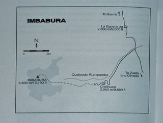
The Map
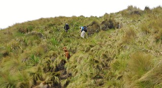
The Approach
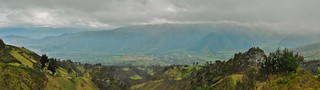
The View
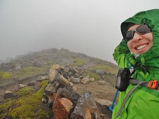
What I Thought Was the Summit!
Our next mountain, Imbabura, is the prominent mountain of Otavalo. According to Yossi Brain, “A large hill with a long walk up it, Imbabura is good for acclimatization and fitness.” I have to agree. The route we took ascended 3,905 ft and took us just over 4 hours to accomplish. At the time, I thought it was the summit, but later we figured out that we were on the summit ridge (since it’s a volcano, it’s not obvious if you’re in a cloud, to see the highpoint!).
Rafael drove us past the village of Chirihuasi (at 9,680 ft), uphill to an elevation of (10,952 ft). He parked his truck by a farmhouse at a wide spot in the cobbled road. There was a shed with a pig tethered in it, which was about 20 feet from the truck. When we hopped out of the truck, a friendly dog approached us. Rafael was friendly with it, so we figured this dog is a regular!

About 10 minutes from the truck, still on the cobbled road.

After hiking for about 20 minutes, we had this pretty view of Ibarra.

Eventually, after about 25 minutes of walking, there was a fork in the road. We left the narrow road and took a left onto the single track.

Taken from the same spot as the last picture, but just looking back at the direction we came from.

Once you turn left at the fork, the single track steepens and climbs a ridge. There were a few other buildings we passed a long the way and some farmers working the fields.

After 50 minutes of hiking, we are now approaching a water tank at 11,320 ft. The trees started to disappear and we could see the ridge ahead.

Trail Signage

Taken from the same spot as the trail signage photo, just looking back at the way we came.

1 hour 15 minutes into the hike, we can see the whole town of Ibarra. What a view!

At 1 hour 20 minutes, we reach the paramo. From now on, it’s going to be a very steep climb!

Looking back at Tilden

At 1 hour and 40 minutes, I’m looking back at our route. You can see the water tank way down on the ridge!

To demonstrate the steepness, I took this picture!

Our friendly guide dog, Perra! She has probably climbed Imbabura a gazillion times. It was awesome to watch her on the third class section. She got under my feet once, though, so for a moment I was annoyed. But, most of the hike, she was a joy to hike with and we really enjoyed her company.

At 3 hours into our hike, after climbing 3,200 ft, we see this sign!

At 3 hours and 50 minutes, we do some 3rd class scrambling. Here’s Tilden making the moves!
The clouds move in and we are fortunate it is not raining. In the fog, Rafael continues to lead the way. I’m very happy we have a guide!

Rafael leading the way.
After this, we were on what we thought was the summit. A cloud had landed on the mountain and we were being coated in a fine mist. In hindsight, we realized we were only on the summit rim, but at the time, it felt like we had reached the summit. Rafael waited while I took the “summit picture” and send a spot message to Dennis. Since it was a personal best record, in terms of altitude, I was really psyched.

Tilden descending back to the trail head.
We managed to get back to the car in 2.5 hours, from the summit rim. So, it was 6.5 hours total, with 8.2 km of hiking and almost 4,000 ft of gain.
Mountain #2 with no view on the “summit”. We decided it was best to just expect a climb in the clouds, to avoid future disappointment!
After the hike up Imbabura, we had to drive back to Quito as the next day we had planned to climb Rucu Pichincha.
So, we got on the highway. Rafael stopped a couple of times, so we could take some pictures. We also stopped to stretch our legs and we got coffee once (yay, more biscochos!).

Here’s a nice shot of Imbabura. You can see how the clouds are retreating after hovering protectively over the summit all day!

Here I am standing over the equator, in Cayambe.

My right foot is in the southern hemisphere while the left one is in the northern hemisphere.

Geological Survey Marker for the Equator

Tilden by the Monument at the Equator

Fuya-Fuya and Imbabura Panorama, taken from the Pan American Highway

We stopped for a few minutes to stretch. At this spot, there was a road side playground and some hiking trails. There were also some signs about the region of Cayambe.

Cayambe Tourist Map

Signage

I was told that the mountain called Cayambe is behind these clouds.

Playing on the swings at Mirador de Oton…having a bit of fun!
When we got back to the Hotel San Francisco, in Quito, I sent Dennis an email, letting him know about the day. I also posted a note on Facebook about my personal best record on Imbabura. In addition to my record, it was Dennis and I’s 12th Anniversary…so there were 2 things to celebrate.
Tilden and I went to dinner in the La Ronda neighborhood and I told him about the La Dame ghost story. I was (again) happy to not be wandering those streets by myself at night. We had a nice dinner and then we went back to the room to get ready for Rucu Pichincha!
Tags: 12th Anniversary, 15er, Chirihuasi, Ecuador, Hiking, Ibarra, Imbabura, Mountaineering