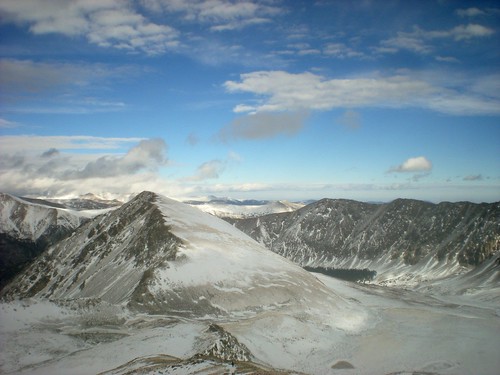
View of Kelso Mountain (Taken From 13,200 ft up Grays Peak)
Grays Peak Summit Video
Posse: Clare, Dave, James, Jeff, Linda & Tom, Lauren, Rick, Rich, Steve and Warren
Rendezvous Time: 6:30am
Winter Trail Head (Bottom Stephens Gulch Road): 7:35am
Start Hiking: 7:55am
Summit of Grays: 2:05pm
Back to Trail Head: 5:45pm
For Trip Report, Topo, Elevation Profile, & More pictures click here:
Plan-Follow Route on Topo to the top of Grays Peak, then head back to TH. Be safe & have fun!

Elevation Profile of Hike to Summit from Winter Trailhead:

Trailhead Muster at 7:45am. Elevation 9,800 ft.

Our first stop, at 8:20am. Elevation 10,190 ft and Distance 0.5 miles.


CMC Hikers in Tight Formation, at 8:35am. Elevation 10,400 ft and Distance 1.2 miles.

Near the Josephine Mine, at 9:30am. Elevation 10,600 ft and Distance 1.6 miles.

Half an Hour After the Summer Trailhead (where we put on snowshoes), at 10:30am. Elevation 11,660 ft and Distance 3.7 miles.

Ninja Spotting (or is it the Unibomber?). Climbergirl self portrait.

Jeff, our Leader In Training, at 11am. Elevation 12,060 ft and Distance 4.4 miles.

Tom Enjoying a Snack at 11:20am. Elevation 12,130 ft and Distance 4.5 miles.

Jeff Points the Way to the Summit of Grays Peak

What Jeff & Posse Was Looking at in Prior Picture

The View of Greys and hour later, at 12:30pm at 5.6 mile mark. Only about 1 mile to go! Top obscured by blowing snow.

After taking the above picture, I turned around got this rad picture of Rick! Elevation 12,900 ft.

Grays Peak Summit Pictures:
Self Portrait

James

Tom

Clare

Lauren

Enough Tomfoolery, time to descend!
Here’s Rick forcefully advancing downward, through gusty winds.

Finally, I get a clear picture of the top of Grays Peak…! I just had to wait until 3:30pm.

Tags: 14er, CMC, Grays Peak, Hiking, Microspikes, Snowshoe Hiking