Posts Tagged ‘Mountaineering’

Mountaineering – Mt. Elbert (14,439 ft)

Saturday, January 17th, 2015

Winter Camping Gear Schmear
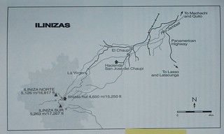
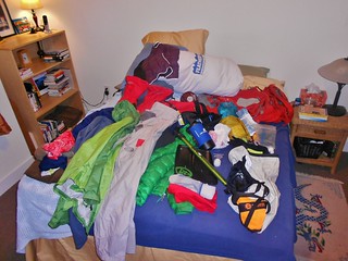
Gear Schmear, for Winter Mountaineering trip up Mt. Elbert

Approaching 11,000 ft on Mt. Elbert
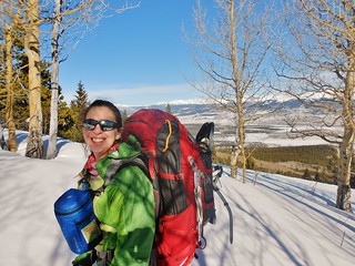
At 11,000 ft and almost to our camping spot. Enjoying the bluebird day.

Mt. Elbert and Bill
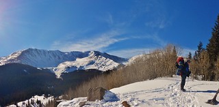
Bill, the CMC Trip Leader. He’s taking a breather before we reach camp. Elbert stands tall behind him.

Silly Summit Shot on Mt. Elbert
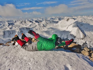
Flying High on the summit of Mt. Elbert!

I wanted to try winter camping and I hadn’t yet climbed Mt. Elbert. So, why not join Bill’s CMC trip which would combine both elements? Bill is leading a trip to attempt Aconcagua later this year, so this trip was a warm up and test of sorts for his participants. Lucky for me, there was a last minute cancellation on his trip, which opened up a space for me, AND my friend, Helen, needed a partner for her tent. It was almost like I was meant to be on the trip, all along!

(more…)

Ecuador – Day 9 – Cotopaxi (19,347 ft)

Friday, November 28th, 2014

Antisana and Chimborazo from Cotopaxi Summit
Antisana and Chimborazo from the summit of Cotopaxi

Cotopaxi Victors
Tilden and Clare on the Summit of Cotopaxi

Cotopaxi Shadow and Ilinizas at Sunrise
The Shadow of Cotopaxi and the Illinizas (see the previous day’s post!)

Cotopaxi Map
The Map

Rafael Descending Cotopaxi
Our Guide, Rafael (photo courtesy of Tilden)

Times
12:00am: Trail Head at 15,100 ft
01:20am: Hut at 15,750 ft *took a 10 minute break
02:20am: Snowline at 16,000 ft *took a 10 minute break to don crampons and rope up
06:05am: At 18,600 ft Watched Sunrise and shadow of Cotopaxi appear by the Illinizas
07:45am: At 19,347 ft On Summit!
08:25am: Began Descent
11:25am: Back at Trail Head

(more…)

Ecuador Day 7 – Illiniza Norte (16,817 ft)

Wednesday, November 26th, 2014

Ilinizas Map
The Map

The Misty Ridge of Iliniza Norte
The Approach

Climber Congo Line up Iliniza Norte
Congo Line at the Top

Clare and Tilden on Summit of Iliniza Norte
The Summit

Our 4th mountain of the week was Illiniza Norte. To climb this mountain, we went roughly 11.5 km with 1,128 m (3,700 ft) of gain. The whole thing took us 7 hours and 10 minutes; including a lengthy stop for tea and another one for lunch.

For the first time during the trip, I had a headache from the altitude. It was just after we crossed 16,000 ft and it disappeared once we began descending. Tilden, on the other hand, finally started feeling good at the altitude and he did awesome.

We were both really happy Rafael knew the route so well. When we got to the top, there were a couple of huge tour groups and we were able to bypass them without roping up. Also, since most of them were stationary on the summit, we didn’t have to worry about them knocking rocks down on top of us while we descended.

(more…)

Ecuador Day 6 – Rucu Pichincha (15,413 ft)

Tuesday, November 25th, 2014

Guagua and Rucu Pichincha Map
The Map

TeleferiQo in Quito
Riding the Gondola (TeleferiQo) in Quito

Rucu Pichincha: A Lovely Ridge Hike
The Approach. It starts on the ridge, then it climbs ever steepening terrain until the last wee bit is 3rd class. The summit is in the clouds, left of frame!

Tilden Stepping up on Rucu Pichincha
Third Class Section…Most Fun bit, but unfortunately only 10 minutes!

Rafael and Tilden on Rucu Pichincha
Rafael and Tilden Enjoying The Summit

For our 3rd mountain, we climbed Rucu Pichincha. It is a unique ascent because it is very close to Quito and the trip starts with a ride on the Gondola! From where we got off on the Gondola, it took us 2 hours and 50 minutes to summit and just under 2 hours to get back.

It’s a great half day acclimatization. While the navigation and hiking is relatively easy during the ridge traverse to the peak, the ascending of the peak itself is not for the beginner. There are cliffs surrounding the entire base of the mountain. Thus, it’s really important to go with a guide on this mountain, or be in the company of an experienced mountaineer who is already familiar with the peak. Clouds are pervasive threats to navigation and the terrain at the top is steep and chossy!

(more…)

Ecuador Day 5 – Imbabura Summit Rim (14,764 ft)

Monday, November 24th, 2014

Imbabura Map
The Map

Rafael, Tilden, and our Perra
The Approach

Imbabura View in the Morning
The View

Clare Near Imbabura Summit
What I Thought Was the Summit!

Our next mountain, Imbabura, is the prominent mountain of Otavalo. According to Yossi Brain, “A large hill with a long walk up it, Imbabura is good for acclimatization and fitness.” I have to agree. The route we took ascended 3,905 ft and took us just over 4 hours to accomplish. At the time, I thought it was the summit, but later we figured out that we were on the summit ridge (since it’s a volcano, it’s not obvious if you’re in a cloud, to see the highpoint!). (more…)