Archive for July, 2014

Mountaineering – Gladstone Peak (13,913 ft)

Saturday, July 26th, 2014

Gladstone Peak from Base of Wilson Peak
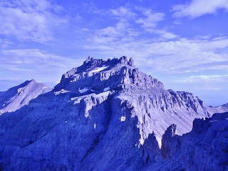
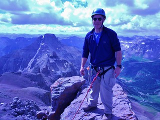
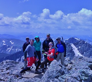
Gladstone Peak taunting us as we stand near the base of Wilson Peak.

Upper Bilk Basin Lake at 12,060 ft
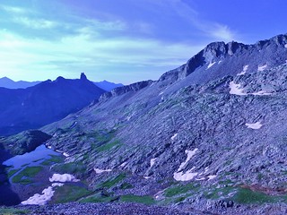
The Unnamed Lake at 12,060 ft and the view of Lizards Head

After a serene evening in Upper Bilk Basin, we awoke to sky full of stars. It was a good sign. Who knows, maybe it would be a clear day. I thought we had a really good chance for the summit, since we were only a couple miles away.

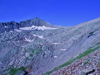
We arrived at the unnamed lake, at 12,060 ft at 6am. The lighting was flat and so the view of Gladstone and Wilson Peak was fuzzy. We headed up to the obvious saddle between Gladstone and Wilson Peak, getting suckered by some cairns.

Then, as we neared the base of Wilson, we realized we were too far from Gladstone. We were hoping to hit the ridge only 0.5 miles from the summit of Gladstone…and now we were about a mile away!

Oh no! My heart sunk. We had wasted quite a bit of time. We looked at the long ridge separating us from our destination and it just looked icky. Rather than take a chance traversing the entire ridge, we descended back to the lake to try again. Maybe in the brightness of full sun, we’d see the proper route.

Gladstone and Wilson Peaks from Lake at 12,060 ft
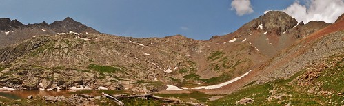
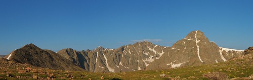
Panorama taken from the Lake, showing Gladstone Peak on the left and Wilson Peak on the right!

(more…)

Mountaineering – Backpack Into Bilk Basin

Saturday, July 26th, 2014

Sunshine Mesa Trailhead - Apres Gladstone Peak
Clare, Meredith, and Helen at the Sunshine Mesa Trailhead

After climbing Teakettle Mountain on Thursday, I found myself in an enviable position. I was in the San Juan Mountains, at the beginning of a weekend, with a reasonable weather window in the near future…Time to climb some more mountains! Giddyup!

Approaching the Bilk Creek Crossing
Lucky for me, Helen and Meredith were thinking the same thing…and before we knew it, the three of us were on our way to Telluride. More specifically, heading to the Sunshine Mesa Trailhead for a backpack into Bilk Basin.

Upper Bilk Basin Camping - Clare's Spot
Would the good weather hold? Would we have the energy, after Teakettle? Would we be thwarted by the treacherous, unsettled chosspile of a mountain that some refer to as Sadstone?

The litany of potential failings raced through my mind as we trundled up Sunshine Mesa road. The road was muddy, steep, and slick. Was this a forbearance of things to come?

(more…)

Mountaineering – Teakettle Mountain (13,819 ft), Ouray, CO

Thursday, July 24th, 2014

Teakettle Mountain from Coffeepot
Teakettle Mountain from Coffeepot. The dark gash in the mountain is the Black Gully!

Clare and Potosi Peak
Climbergirl and Potosi Peak

Ever since climbing Mt. Sneffels, in July of 2013, I had a desire to climb the two centennial 13’ers flanking it. To the west of Sneffels, Dallas Peak stands guard while to the east, there’s Teakettle Mountain. Both captured my imagination and so I must climb them!

Bruce the Champion of Teakettle Mountain
Trip Leader, Bruce, on the summit of Teakettle Mountain

When I saw Bruce’s trip posted on the CMC website, I called him immediately. We had a pleasant conversation and we agreed to meet in a climbing gym, prior to the trip. The last section of Teakettle Mountain involves 5th class climbing; so it’s important people understand rope management, basic knots, safety, and climbing. Them gym meet-up went well, so the trip was on!

Trip Participants: Bruce (Leader), Tom, Frank, Meredith, Lisa, Helen, and I

Our Progress:
Leave Yankee Boy Basin TH: 5:10am
Base of Coffeepot: 7:40am
Base of Black Gully: 8:10am
Above Black Gully: 8:25am
Base of 5th Class Pitch: 9:10am
Start Climbing: 9:15am
Finish Climbing: 10:45am
Below Black Gully: 11:30am
Started Awful Scree Descent (We went down the direct route, not up/over Coffeepot ledge): 11:45am
Finished Awful Scree Descent: 12:40pm
Return Yankee Boy Basin TH: 1:30pm

(more…)

Mountaineering – Dyer Mountain (13,855 ft)

Sunday, July 20th, 2014

Feeling Lazy on Dyer Mountain
Naptime on Dyer Mountain!

Bobby on Summit of Dyer Mountain
Bobby enjoying the summit of Dyer.

After leading the CMC Half Marathon Holy Cross Loop Hike on Friday, I enjoyed a lazy Saturday morning at the Halfmoon Campground. I packed up camp and talked with Bobby about potential bonus peaks for Sunday.

I was anxious about doing the bonus peak solo, since I was a bit fatigued from leading the trip, so I was really happy to have company. We “shopped around” for low commitment peaks in both my 13’ers and 14’ers books. There were so many available, but it didn’t take long for us to decide on one…Dyer Mountain, it is!

Advantages being:
1. It’s on the way home from Minturn.
2. We can get really awesome pizza at High Mountain Pies.
3. My Subaru will have no problem making it to the TH.
4. It is a straightforward climb.
5. Camping near the TH is easy to find. Now, even easier…GPS: N 39 deg 13.732 min. W 106 deg 12.655 min
6. Neither of us had climbed it, yet.

About the TH beta for Iowa Gulch, if you have the Roaches 13er book, ignore the directions in there, they are outdated due to the road being paved much higher up than it was 10+ years ago. The best bet is to use 14’ers.com Iowa Gulch TH directions.

So, on Sunday, Bobby and I hiked from the Iowa Gulch TH to the summit of Dyer Mountain.

(more…)

Mountaineering – Mount of the Holy Cross, A Half Marathon Hike, CMC

Friday, July 18th, 2014

CMC Group Summit Holy Cross Ridge
My CMC posse on the summit of Holy Cross Ridge (13,831)
L to R: Bobby, Jane, Clare, Fred, Marshall, and Andreas

CMC Group Summit Mt of the Holy Cross
And an hour later, here we are on Mount of the Holy Cross (14,005 ft)
L to R: Bobby, Fred, Jane, Marshall, Clare, and Andreas

On Friday, I led a Colorado Mountain Club trip on a half marathon loop hike in the Holy Cross Wilderness. With a beautiful weather forecast and an early start, we were bound to have a great day. I was excited about the trip as I had been ruminating about it for months. I was also really psyched to be on the trail with this posse; they are talented, fit, and superb mountaineers!

Our Route:
1. Departure from the Halfmoon Campground at 4:25am.
2. Started hiking south on the Fall Creek Trail at 4:40am.
3. We turned right and headed west up the Notch Mountain trail, hooking up with the Halo route at ~6:00am.
4. Arrive at Notch Mountain Shelter at 8am.
5. We continued heading south and then west to Holy Cross Ridge at 10:50am.
6. From there, we went northeast to Mount of the Holy Cross at 11:50am.
7. Then, we took the standard North Ridge route back to Halfmoon Trailhead, finishing at 4:30pm.

Mt of the Holy Cross Panorama from Notch Shelter
We hiked 13.8 miles, with 5,400 ft of gain, in 12 hours (including several long breaks).

(more…)