Posts Tagged ‘Tenmile Range’

Mountaineering – Crystal Peak (13,852 ft) and Bonus 13ers

Saturday, September 13th, 2014

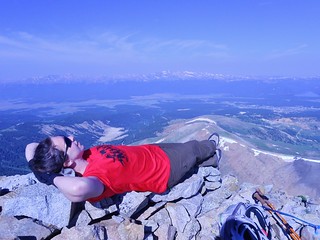
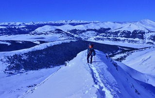
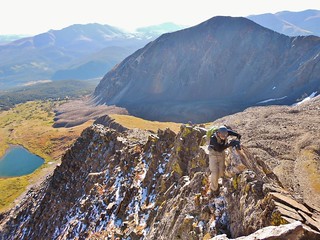
Zach Clutching the Spine of Father Dyer

Smiles on Crystal Peak Summit
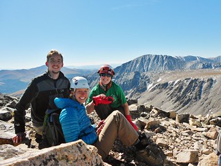
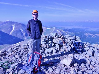
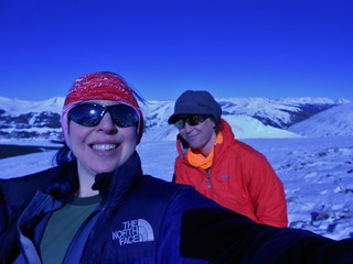
Zach, Beth, and Clare on Crystal Peak

Crystal Peak and Peak 10
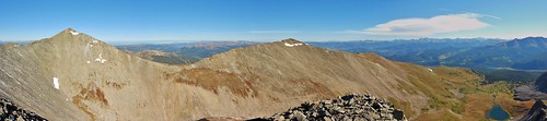
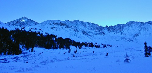
Crystal Peak and Peak 10, taken from Father Dyer

Father Dyer, Crystal, and Peak 10 Topo Map with Waypoints
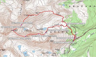
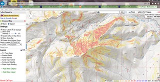
Our loop hike of Crystal Peak Cirque

In the Colorado Scrambles book, Mr. Cooper touts the climb of Father Dyer as, “a good introduction to the “art” of scrambling, offering some exposed but not sustained climbing and even a bit of loose rock to initiate the budding scrambler.”.

The climb of Father Dyer’s East Ridge sounded like a super fun way to climb Crystal Peak; a Centennial 13er just waiting to be ticked off our lists. Beth’s brother, Zach, is quickly building his scrambling repertoire, so this was a great route for honing his skills. By throwing in Peak 10 (13,633 ft), the #178 ranked Bicentennial as a bonus, we expanded the size of our loop hike and had a real feeling of accomplishment by completing the cirque. (more…)

Mountaineering – Dyer Mountain (13,855 ft)

Sunday, July 20th, 2014

Feeling Lazy on Dyer Mountain
Naptime on Dyer Mountain!

Bobby on Summit of Dyer Mountain
Bobby enjoying the summit of Dyer.

After leading the CMC Half Marathon Holy Cross Loop Hike on Friday, I enjoyed a lazy Saturday morning at the Halfmoon Campground. I packed up camp and talked with Bobby about potential bonus peaks for Sunday.

I was anxious about doing the bonus peak solo, since I was a bit fatigued from leading the trip, so I was really happy to have company. We “shopped around” for low commitment peaks in both my 13’ers and 14’ers books. There were so many available, but it didn’t take long for us to decide on one…Dyer Mountain, it is!

Advantages being:
1. It’s on the way home from Minturn.
2. We can get really awesome pizza at High Mountain Pies.
3. My Subaru will have no problem making it to the TH.
4. It is a straightforward climb.
5. Camping near the TH is easy to find. Now, even easier…GPS: N 39 deg 13.732 min. W 106 deg 12.655 min
6. Neither of us had climbed it, yet.

About the TH beta for Iowa Gulch, if you have the Roaches 13er book, ignore the directions in there, they are outdated due to the road being paved much higher up than it was 10+ years ago. The best bet is to use 14’ers.com Iowa Gulch TH directions.

So, on Sunday, Bobby and I hiked from the Iowa Gulch TH to the summit of Dyer Mountain.

(more…)

Mountaineering – Mt. Silverheels – Attempt

Sunday, March 30th, 2014

Bross, Cameron, and Lincoln from Scott Gulch
Bross, Cameron, and Lincoln from Scott Gulch.

Erin and Silverheels
Erin fighting to stay vertical en route to Mt. Silverheels.

Cal Topo Silverheels
Cal Topo Map of Slope Steepness, for avalanche preparedness.

Erin and I failed miserably at ascending Mt. Silverheels. We properly mitigated all the objective hazards, but nothing could account for the onslaught of perpetually high wind. It was blowing much stronger than what I experienced with Slava on Longs Peak and I wouldn’t be surprised if it was gusting between 90-100 mph.

I fell over 3 times and I dared not drop my pack for fear that I would land in Oz. The forecast was for high winds gusting between 30 and 40 mph. Next time I try this mountain, I’m only going to go if the forecast is between 0-10 mph gusts…that way if they are off by 50 mph, then I might actually be able to summit!

(more…)

Mountaineering – Atlantic Peak (13,941 ft)

Sunday, January 19th, 2014

Climbergirl and Nerdysheep on West Ridge of Atlantic
Rather than loafing around all day, watching the Bronco’s play the Patriots, Erin and I decided to go climb a mountain.

I stole Dennis’ Bronco shirt as a token of our support. My plan was to wear it on the summit!

Erin Enjoying Exposure on Atlantic West Ridge
In order to get there, we would need to climb 2900 feet of gain with a total trip distance of 5.4 miles, negotiating snow drifts, potential avalanche spots, and cornices.

The question is; would we conquer the mountain without succumbing to Old Man Winter?

Mayflower Gulch Basin
Pacific Peak Bathed in Early Morning Sun and the long, mellow angled ridge of Atlantic, in the foreground. Mt. Fletcher is off to the right, connected to Atlantic by a foreboding snaggle-toothed ridge!

I had my eyes set on the west ridge of Atlantic ever since reading about it in Mr. Cooper’s Colorado Snow Climbs book. Having been into the Mayflower Gulch on a prior attempt of Mt. Fletcher, I was familiar with the area; one of convenience and beauty!

(more…)