Archive for August, 2013

Mountaineering – Ellingwood Point and Blanca Peak, Sangre De Cristo Wilderness, CO

Saturday, August 31st, 2013

Knife Edge of Ellingwood Point?
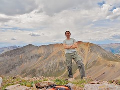
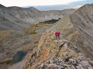
Doug Climbing the Southwest Ridge of Ellingwood Point

Doug and Clare Summit of Ellingwood Point
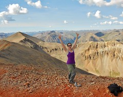
Summit of Ellingwood Point (14,042) after climbing the Southwest Ridge.

Blanca Peak Headstand (14,345 ft)
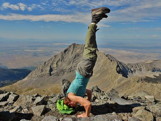
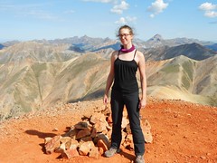
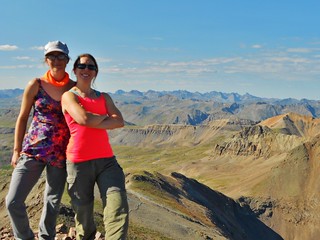
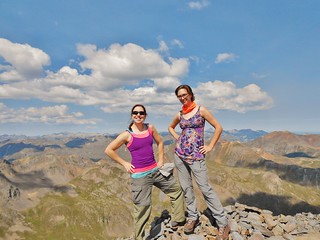
Summit of Blanca Peak (14,345 ft) after traversing the Northwest ridge from Ellingwood Point.

Lake Como Road - 3 hrs of Hiking - Lake Como!
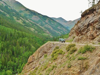
Lake Como and the eponymously named “Road”, left of frame. If you’re having trouble seeing the road, because of the boulders, it’s because the road *is* the boulders!

For an excellent recap of the Lake Como Road, I entreat you to watch the following awesome video, by Rockfrogs 4WD Club. These guys demonstrate extreme skill maneuvering their tricked out trucks up that road! It is one of the most challenging roads in our country, and they manage to get their trucks past Lake Como, all the way up to Blue Lakes. Amazing!

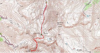
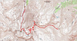
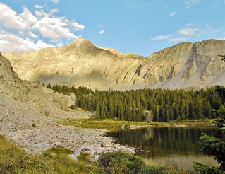
On Friday, Doug and I drove from Denver to the Lake Como Trailhead, were delayed by a train for 20 minutes on the way there, hike up the arduous Lake Como Road, scope out the start of the climb, and then set up base camp at Blue Lakes.

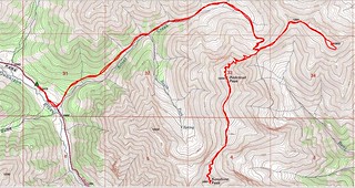
Saturday we tackle the Southwest Ridge of Ellingwood Point, traverse to Blanca Peak along the Northwest Ridge of Blanca, climb Blanca Peak, descend to base camp, pack up, hike back to the truck, and drive back to Denver.

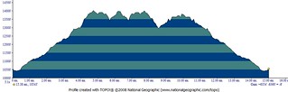
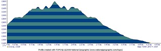
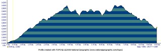
It takes us approximately 24 hours to complete our mission, from the time we leave the truck until the time we return. The trip was hectic and frustrating at times; but supremely rewarding and gratifying, as well. We travelled roughly 15 miles with 6,500 ft of gain.

If the Southwest Ridge of Ellingwood Point were more easily accessible, it would be completely plastered with scramblers every day! The rock on this ridge is of high quality and, for the most part, secure. The position of the route and the exposure produces an extremely enjoyable route! Do IT!

Thank you to skier25, who posted a fabulous trip report, with pictures, of the Ellingwood Point – Southwest Ridge on 14ers.com!

(more…)

Mountaineering – San Juan Peak Bagging Extravaganza, Day 3

Saturday, August 17th, 2013

Day 3 of SJPBE did not start out very well. It was raining at 4:30am. So we slowly got things ready while it was raining. We were not excited about hiking in the rain. Finally, around 6am, it cleared up a little and became just a slight sprinkle.

Good enough! We charged down the road; two girls on a mission. We had no idea how our day would go, we just knew it would be a good day!

Summit of Redcloud Peak (14,034 ft) Erin All Fired Up on Redcloud Peak (14,034 ft)
Clare and Erin all fired up on Redcloud!

Erin and Clare Walking on Sunshine (14,001 ft)
We’re Walking on Sunshine…Yeaaaaah!

Clare on Summit of Pt 13,832
On Summit of Pt. 13,832 (A Centennial) with Sunshine and Redcloud behind me.

Redcloud, Sunshine, Pt 13,832 Topo Map
Map of Approximate Route

Redcloud, Sunshine, and Pt 13,832 Elevation Profile
Elevation Profile showing 15 miles total with 6,300 ft of elevation gain. Whew!

(more…)

Mountaineering – San Juan Peak Bagging Extravaganza, Day 2

Friday, August 16th, 2013

Erin and Clare on Summit of Jones Mountain (13,860 ft)
All Smiles on Summit of Jones Mountain (13,860 ft). The Grenadier Mountains are behind us!

Jones Mountain Topo Map
Topo Map, with our approximate route.

Jones Mountain Elevation Profile
Elevation Profile, showing our gain of ~2,000 ft with a distance of 4.25 miles. We left high camp at 12,400 ft, hiked to the summit of Jones Peak, and then back to the truck at 11,400 ft.

Then, we moved the truck to the Grizzly Gulch Trailhead to secure our camping spot for that night. As it was a Friday, we wanted to get to Grizzly Gulch before the masses from grasslands arrived.

(more…)

Mountaineering – San Juan Peak Bagging Extravaganza, Day 1

Thursday, August 15th, 2013

Today our schedule for the day was to climb Handies Peak (I also did the bonus bi-centennial, Pt 13,795) and then set up base camp (somewhere above 12,400 ft) in American Basin. We had a great day and it went exactly as planned.

Summit of Handies Peak (14,048 ft)
On the summit of Handies Peak (14,048 ft)

Clare on Summit of Pt 13,795
On the summit of bonus Bi-Centennial, Pt. 13,795

Handies Peak and Pt. 13,795 Topo Map
The Topo Map, with our approximate route and camp spot.

Handies Peak and Pt 13,795 Elevation Profile
The Elevation Profile, for Handies and the bonus point, showing 4,900 ft of gain with 9.5 miles.

(more…)

Mountaineering – San Juan Peak Bagging Extravaganza, Drive Out

Wednesday, August 14th, 2013

The San Juan mountains of Colorado have some of the most rugged, remote, and beautiful peaks. Erin and I wanted to try our hand at bagging several summits in one long weekend. Our three day schedule was jam packed:
Day 1: Handies Peak (With optional Bi-Centennial Pt. 13,795)
Day 2: American, Jones, and Niagara (As many as we could get of these!)
Day 3: Redcloud and Sunshine (With optional Centennials Pt. 13,832 and Pt. 13,811)

Thus, on a Wednesday, I drove to Erin’s and we filled Bertha with mountaineering gear, coolers, beer, and camp chairs. We were both giddy with excitement; to get the heck out of Denver and into the mountains.

Road to American Basin
Bertha on Cinnamon Pass Road

(more…)